|
We took a break from the regular format of our webinars to host a Show-and-Tell! This format was to help us start talking about the 3rd theme: How are water management and climate change interacting to determine the magnitude, extent, and duration of saltwater intrusion within and across the NACP? Although we know that humans have altered the hydrology across the coastal plain, the extent to which human activities lead to variation in SWISLR impacts is not well known. Regional differences in water management practices create areas of “weird” water movement since human infrastructure can potentially constrain the natural hydrological processes through flow control technologies. Variabilities within the water infrastructure makes the interactions between water management and water harder to understand regionally. When predicting the timing, magnitude and duration of saltwater intrusion and sea level rise “bathtub” models are typically used that assume topography as the dominant driver of vulnerability. However, the coastal plain ecosystem is dependent on human decisions of water management and infrastructure. Therefore, to better understand the full impact of SWISLR we require models that integrate sea level rise, rainfall-runoff relationships, evapotranspiration, natural geomorphology, water infrastructure (canals systems, dikes, levees) and water management (pumps, check dams, irrigation, groundwater extraction). In the SWISLR Show-and-Tell we invited RCN members to tell us about the weird water where they work and live: 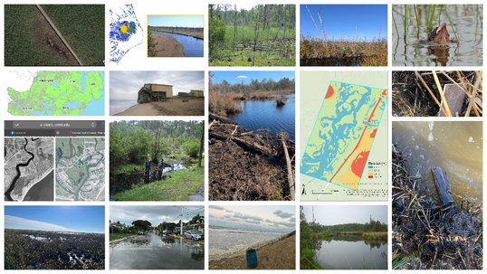 Some alternatives to photos were Ashley Helton's coastal viewer, Xi Yang's drone video, and Jean-Christophe Domec's site info. You can watch everyone's description of their photos here.
0 Comments
Leave a Reply. |
AuthorsKiera O'Donnell:[email protected] Archives
March 2024
Categories |
 RSS Feed
